intense north atlantic storm producing 19 – meter significant waves near main shipping lanes

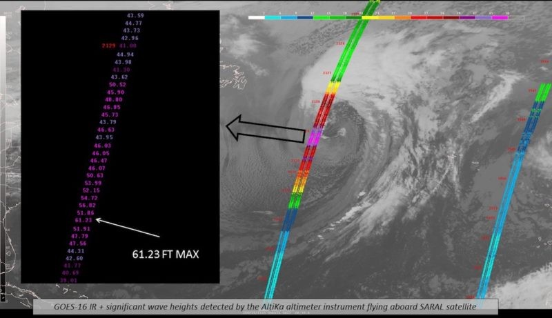
A satellite pass observes a max significant wave height of 61.23 feet in the North Atlantic on Tuesday, February 20, 2018. Credit: NOAA

An intense low pressure system in the North Atlantic was producing significant wave heights of an incredible 19 meters (62 feet) on Tuesday, according to the National Weather Service.

This is a very dangerous storm with hurricane force winds and extreme waves in some of the main shipping lanes between Europe and the United States.

The NOAA NWS Ocean Prediction Center has been monitoring the storm since this weekend as it rapidly intensified overnight on Saturday, developing hurricane force winds in excess of 64 knots by Sunday morning.

The latest NOAA OPC analysis now shows a frightening max significant wave height of 19 meters, up slightly from the 18.3 meters (60 feet) detected earlier on Tuesday. That’s the equivalent of a six-story building.

At these heights, this storm could set a new record for this part of the Atlantic.
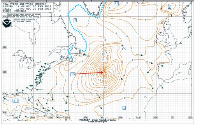
NOAA OPC significant wave height analysis shows an incredible max significant wave of 19 meters (62 feet) over the N Atlantic on February 20, 2018 at 1200 UTC. 

Keep in mind, significant wave height is the average height of the tallest one-third of waves (from trough to crest), so individual waves are likely to be much, much bigger.

This storm poses an extreme danger to ships at sea as it has tracked eastward at a fairly low latitude over some of the main shipping channels connecting North Europe and Mediterranean ports and US East Coast and Gulf ports.

The good news, however, is this monster is forecast to weaken rapidly over the next 24 hours.
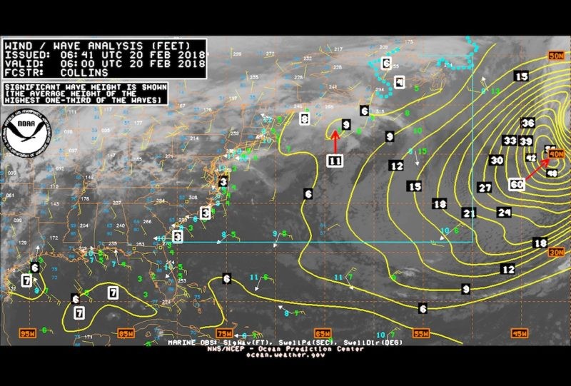
A NOAA OPC wave height analysis shows significant waves of 18.3 meters (60 feet), February 20, 2018 at 06:00 UTC

Hot this week

ο κάλαμος σχεδιάζει το 2030 — ο καστός ακολουθεί, η ιθάκη πότε;

ένα φιλόδοξο σχέδιο 45 έργων και 23 εκατομμυρίων ευρώ...

χάσαμε τ’ αυγά και τα καλάθια νιόνιο

μια παιδική μνήμη από το Περαχώρι του 1952, κάτω...

η φωτιά της καρδιάς και τα μπολερό

στη νότια αμερική της φτώχειας, η μουσική, ο χορός...

ποια φέρουσα ικανότητα της ιθάκης; για γλάρο γιαχνί συζητάμε

ωραία τα σχέδια για περισσότερους επισκέπτες, αλλά πρώτα πρέπει...

καιρικά μοντέλα και πιθανό χαμηλό στη μεσόγειο

τι δείχνουν σήμερα για την περιοχή μας και γιατί...

Topics

ο κάλαμος σχεδιάζει το 2030 — ο καστός ακολουθεί, η ιθάκη πότε;

ένα φιλόδοξο σχέδιο 45 έργων και 23 εκατομμυρίων ευρώ...

χάσαμε τ’ αυγά και τα καλάθια νιόνιο

μια παιδική μνήμη από το Περαχώρι του 1952, κάτω...

η φωτιά της καρδιάς και τα μπολερό

στη νότια αμερική της φτώχειας, η μουσική, ο χορός...

ποια φέρουσα ικανότητα της ιθάκης; για γλάρο γιαχνί συζητάμε

ωραία τα σχέδια για περισσότερους επισκέπτες, αλλά πρώτα πρέπει...

καιρικά μοντέλα και πιθανό χαμηλό στη μεσόγειο

τι δείχνουν σήμερα για την περιοχή μας και γιατί...

αργοστόλι: 11.000 κάτοικοι, 1.166 θέσεις airbnb και έσοδα 14,2 εκατ. ευρώ

μια ενδιαφέρουσα έρευνα του Portoni.gr και το ερώτημα που...

πώς πολεμά η ευρώπη την ερημοποίηση περιοχών

από την ισπανία και τη σαρδηνία μέχρι τα νησιά...

οι τράπεζες ευημερούν, ο λαός φτωχαίνει

άρθρο γνώμης με τεκμηριωμένα στοιχεία του δδμανιά Με άξονες: κέρδη δισεκατομμυρίων...

Related Articles

Popular Categories